

Ask Andy – Our GLOBEClaritas expert!
Q: Is there a way to interpolate irregular land datasets in GLOBEClaritas?
A: Yes! There are two methods using GLOBEClaritas – the MISSING/RUNMIX approach and using the OFFREG/DEOFFREG method.
Modern nodal seismic acquisition has resolved a lot of the issues relating to poor spatial sampling on land datasets. The number of receivers laid out can be greatly increased and consequently, the receiver spacing can be reduced, meaning spatial aliasing is less of an issue. However, for vintage or legacy datasets poor spatial sampling and therefore spatial aliasing remains a problem.
The challenge of removing linear noise
Unlike, marine datasets, it is often important to preserve the acquired source-receiver coordinates and offsets for surface consistent residual statics and other processing steps. Removing linear noise can be challenging if the data is spatially aliased, therefore like marine data, to effectively remove linear noise we often need to improve spatial sampling allowing us to unwrap the aliasing, but we also need to preserve the original geometry as acquired.
In GLOBEClaritas there are two methods we can use to improve the spatial sampling on Land datasets.
MISSING/RUNMIX approach
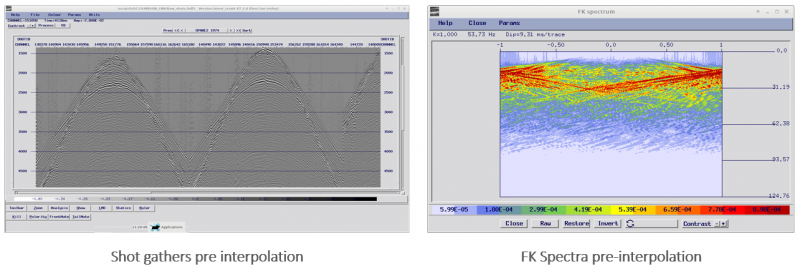
Let’s first take a look at the MISSING/RUNMIX approach to interpolate additional channels/offsets within a gather or ensemble, preserving the original seismic traces.
We initially re-number the Channels so that they have an increment of two i.e. 1,3,5 and so on, this allows the MISSING module to interpolate dead traces where channels are missing at channels 2,4,6, etc.
The RUNMIX module can then be used to interpolate amplitudes onto the interpolated traces. The RUNMIX module has the option to work only on traces that have zero amplitude on input, in this way the input traces are unaffected by the RUNMIX process.
Prior to interpolation, we need to unwrap any aliasing to prevent the risk of locking the aliased noise train into the gather. To do this apply an NMO correction to the data before interpolation, typically we would use a suitable constant velocity which can be backed off-post interpolation.
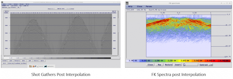
Note: Selection of the NMO velocity would require some testing to select an optimum velocity, we are not looking to flatten primaries as such but rather to select a velocity that unwraps the aliasing without adversely affecting the desired signal so that the interpolation is accurate. Below is a shot gather before and after interpolation using this approach.
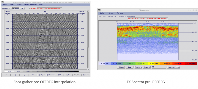
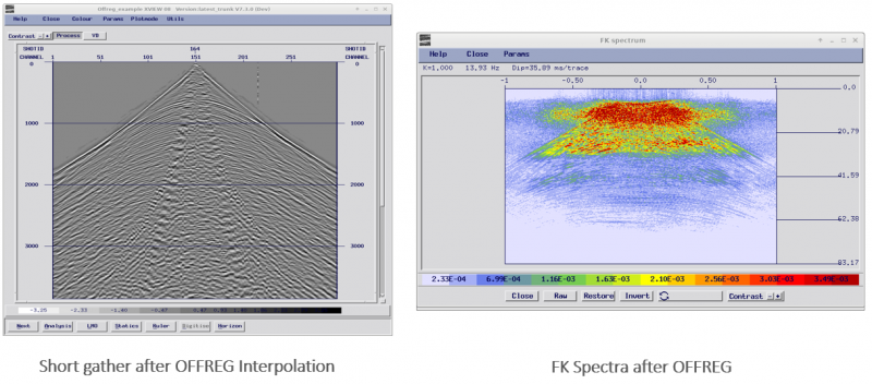
OFFREG/DEOFFREG Method
Alternatively in GLOBEClaritas, we can use the OFFREG/DEOFFREG modules, this method interpolates from your irregular grid onto your defined regular grid with all traces output from OFFREG being interpolated.
As long as you are up sampling spatially, the originally acquired OFFSETS can be preserved in the header and after denoise the DEOFFREG module will interpolate back onto the original irregular offset grid. This means you can apply your preferred noise attenuation process to the dataset having unwrapped any spatial aliasing present in the dataset, making linear noise attenuation more effective.
As with the RUNMIX approach, we do need to select a suitable constant velocity to use to NMO correct the input data, the NMO correction is built into the OFFREG/DEOFFREG modules but the same considerations apply – we are trying to unwrap the aliasing so it’s not locked into the interpolated gather and that desired signal is still effectively interpolated.
Robust and Effective
Both these methods provide a robust and effective method of unwrapping spatial aliasing, making the removal of problematic linear noise more successful. In practice you can use either method for 2D datasets, and for 3D data, I would recommend using the MIISSING/RUNMIX approach, you can use the OFFREG/DEOFFREG method but each 3D Shot gather would need to be split into separate receiver line components (effectively a 2D shot gather) which makes the workflow more complex.
If you need assistance developing flows to interpolate your Land 2D/3D gathers the GLOBEClaritas team would be happy to help and provide example flows on request. Please get in touch below.
GLOBEClaritas Enquiries
If you would like to know more or have questions please use the form to get in touch with one of our experts.