PRO Brings Your Data
To Life In Less Time

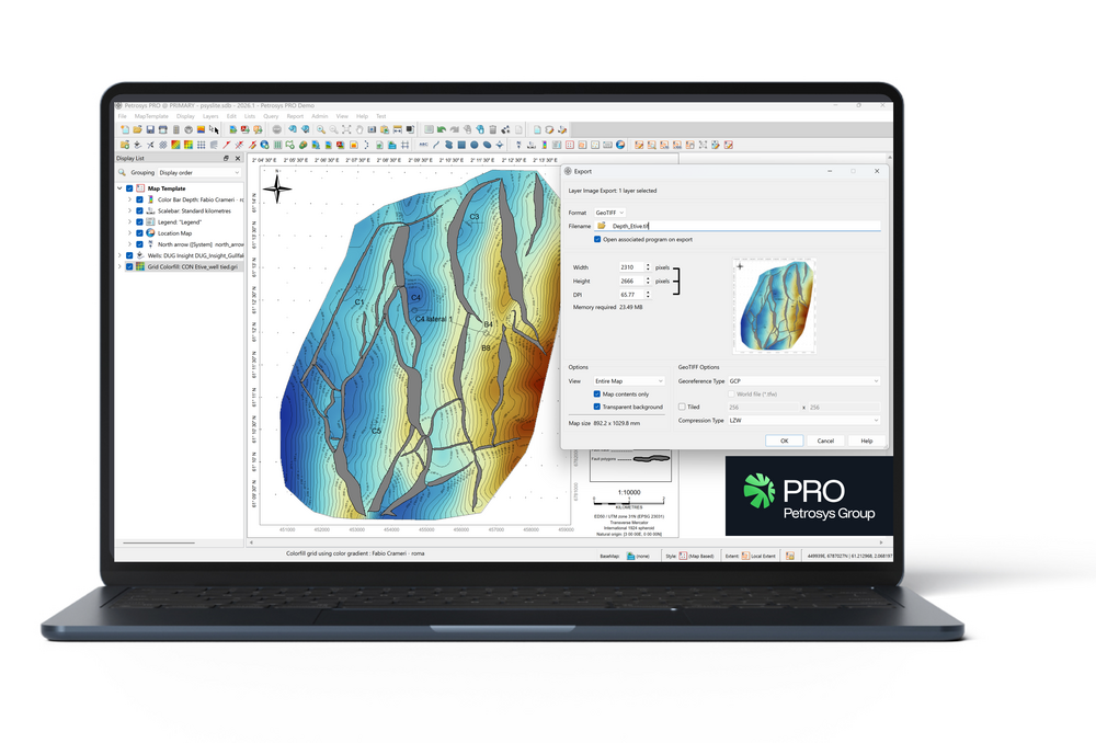
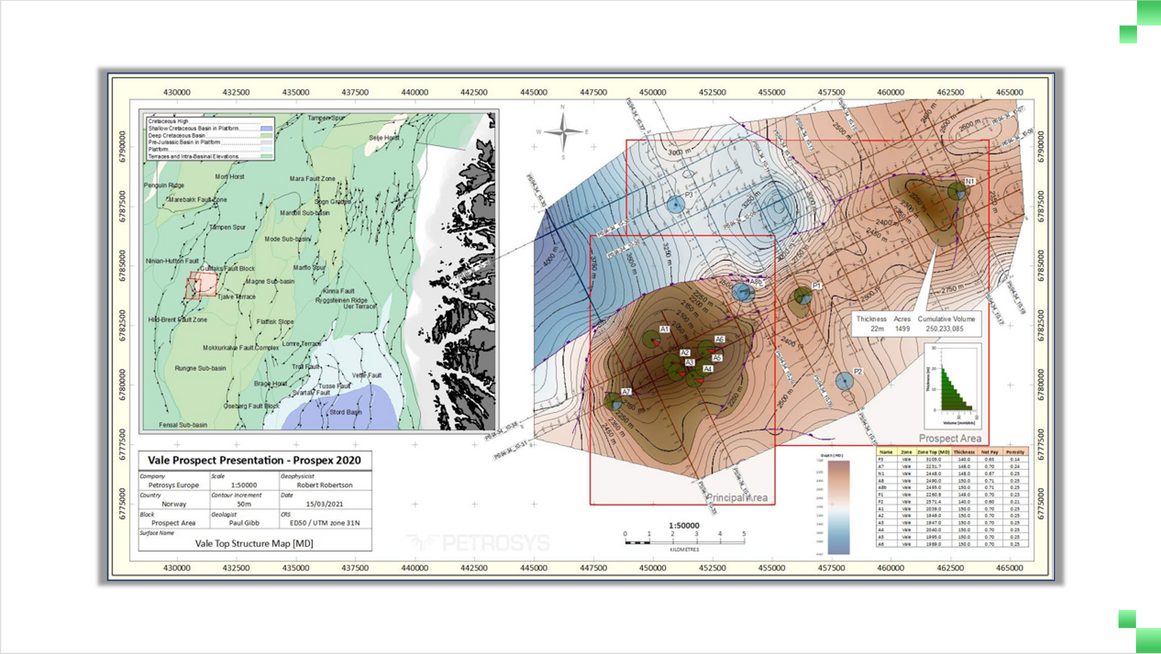
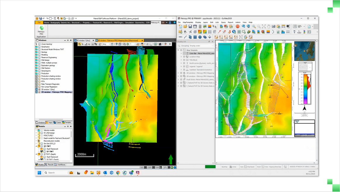
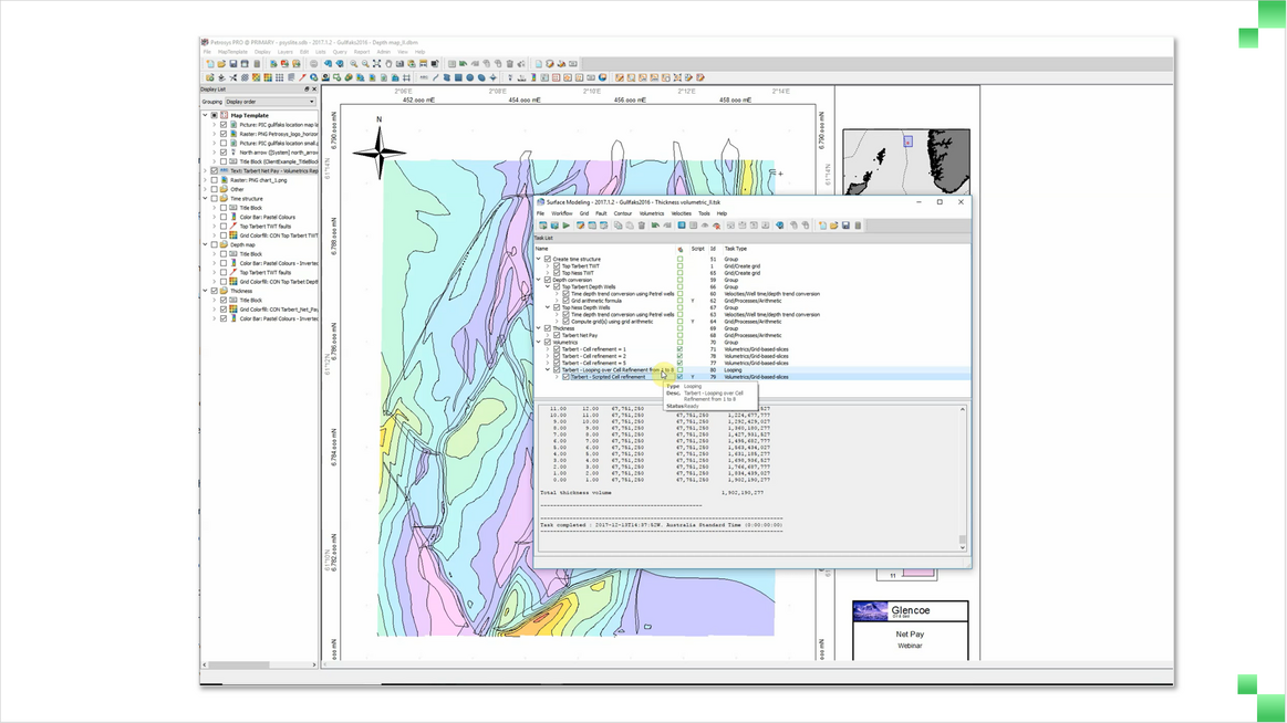
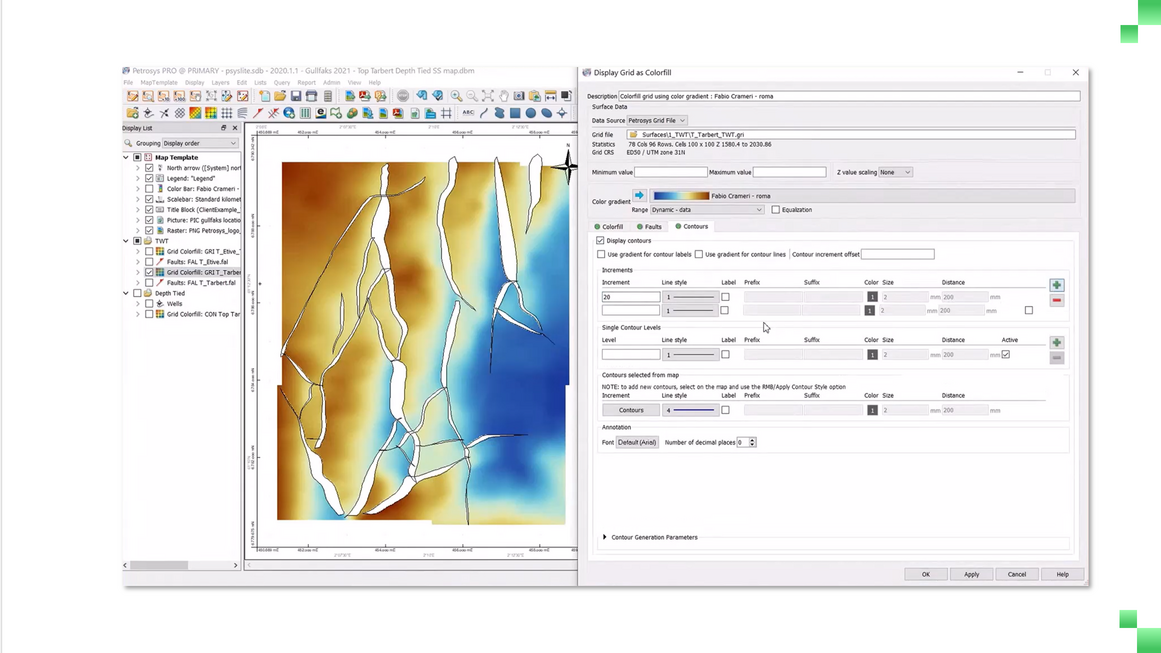
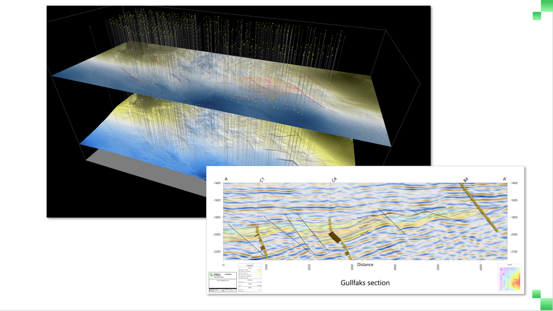
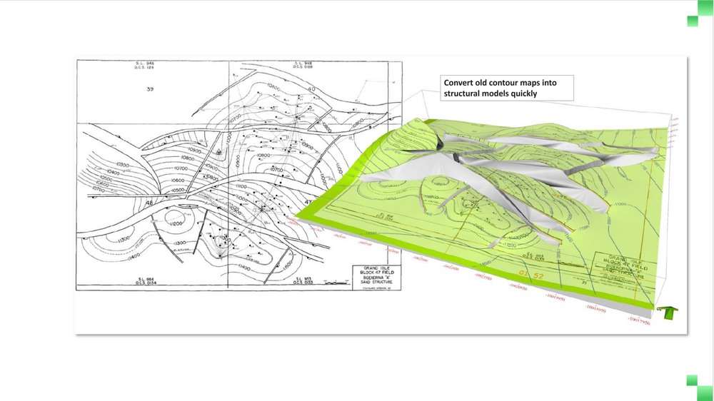
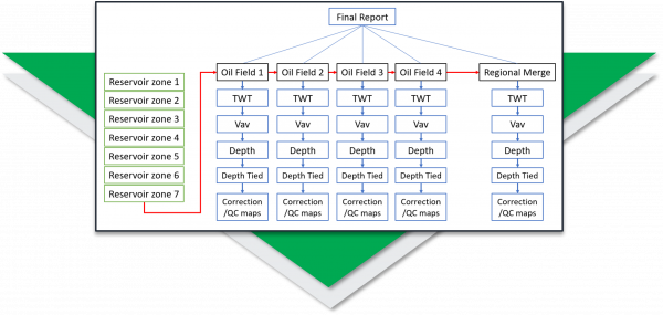
Without a clear picture of the subsurface, it’s difficult to know where to focus resources, and projects often stall. PRO is purpose‑built subsurface mapping and modeling software that helps geoscientists and data managers build accurate structural models, update them quickly and share professional‑quality maps so your team can make financially sound decisions about where to focus exploration and development resources.

PRO

“PRO has cut our project start-up time by around a third by allowing geoscientists to screen and select data themselves, with less reliance on geotechs and data managers.”

What Can You Do With PRO?

Geoscientists face constant challenges, from building highly complex structural models accurately showing an area of interest to sharing these results with stakeholders using limited tools. PRO addresses these challenges by connecting directly to exploration, production, and GIS data sources, creating a single environment for seismic, well, and geoscience data.
PRO Create Polished Maps

Create Polished Maps Faster

With high-quality map templates, you can create professional maps faster and manage regional grid data more efficiently; advanced time-to-depth conversion and contour editing tools allow you to incorporate geological knowledge and insights.
PRO Connectivity

Connect Your Data

Spend less time exporting and converting files. PRO connects to multiple G&G and GIS applications so you can use data in its native format or transfer and convert it between systems.
PRO Surface Modeling

Create Realistic Surface Modeling & Volumetrics

Move from interpretation to volumetric estimation with accountable, repeatable results. Quickly compute realistic surface models, manipulate structural and attribute grids.
PRO Edit Easily

Edit Easily

Black-box tools often make it hard to apply geological judgment. PRO's flexible editors let you impose your geological opinion on surfaces by editing faults, polygons and contours, so your expertise shapes the final model.
PRO 3D Viewer and X Sections

Bring Subsurface & Assets Into Perspective

See relationships between surfaces, exploration and production assets with the 3D Viewer and X Section for advanced visualisation. Monitor inputs to surface computations and output surfaces
PRO Raster images

Digitize Legacy Maps In A Fraction of the Time

Converting legacy maps into a digital format to make them more usable is tedious, time-consuming and prone to errors. With PRO’s advanced tracing and editing tools, you can do this in minutes instead of hours.

PRO Capabilities That Bring Your Subsurface Data to Life

PRO combines advanced mapping and modeling capabilities to transform complex subsurface data into clear, actionable insights.

Mapping & Visualisation

Create accurate and visually compelling maps that communicate clearly across your organisation.

  • Fast, publication-quality outputs: Produce high-standard presentation-ready maps in minutes using live subsurface data.
  • Consistent standards: Apply corporate templates for a uniform look across teams and projects.
  • Flexible editing: Refine contours and layers to apply geological insight where it matters most.
  • Visually clear results: Layer wells, seismic, and other subsurface data with intelligent legends and map controls.

Connectivity & Exchange

Create accurate and visually compelling maps that communicate clearly across your organisation.

  • Fast, publication-quality outputs: Produce high-standard presentation-ready maps in minutes using live subsurface data.
  • Consistent standards: Apply corporate templates for a uniform look across teams and projects.
  • Flexible editing: Refine contours and layers to apply geological insight where it matters most.
  • Visually clear results: Layer wells, seismic, and other subsurface data with intelligent legends and map controls.

Surface Modeling & Volumetrics

Build high-quality surface models and dependable volume estimates with trusted, repeatable processes

  • Model from multiple sources: Combine data from multiple applications and datasets in a single, seamless workflow.
  • Reliable surface generation: Handle complex structures and faults accurately to produce geologically sound models.
  • Efficient, automated workflows: Configure and repeat modelling steps easily to test new data or ideas.
  • Accurate volumetrics: Calculate definitive, review-ready reserve estimates with intuitive tools and clear reporting.

Who Uses PRO?

Anyone who needs to create or share subsurface mapping data will use PRO. Geologists can share the data with government bodies, joint venture partners, or with colleagues to convey their understanding so they can make confident decisions.

  • Executives use PRO for its excellent data integration and easy production and presentation of quality maps.

  • Geophysicists use it for fast and easy depth conversion.
    Geologists use it for probabilistic and deterministic volumetrics.

  • Explorationists use it for its superior generation, particularly near faults, and gridding algorithms.

  • Production geologists use its repeatable workflows to integrate new data and update outputs.

“Having prospect and regional data in one place, with the right assessment tools, has really improved how our geoscientists and engineers work together.”

Where PRO Fits Into Your Workflow

PRO gives teams a consistent, trusted framework for making better decisions with subsurface data. It fits seamlessly into existing workflows, no matter where they are in the project lifecycle.
1

Exploration

Quickly identify prospects and refine interpretations by combining seismic, well, and GIS data into a single, high-quality map. PRO’s advanced gridding and surface generation tools give exploration teams a competitive edge in evaluating new opportunities.
2

Appraisal

Quickly identify prospects and refine interpretations by combining seismic, well, and GIS data into a single, high-quality map. PRO’s advanced gridding and surface generation tools give exploration teams a competitive edge in evaluating new opportunities.
3

Development & Production

Keep field models current with repeatable workflows that update maps, depth conversions, and volumetrics as new data arrives. Share results

PRO Success Stories

Use Case
Regional mapping

Exploration Team Consolidates Regional Maps

Use Case
legacy raster images

Company Converts Legacy Data To Digital Formats

Use Case
Improve accuracy of maps

Improving Geological Accuracy of Subsurface Maps

FAQs

Frequently Asked Questions About PRO

What kinds of data can PRO access?

PRO connects directly to multiple geoscience and GIS applications, so you can work with seismic, well and other specialised data without exporting or converting files. It also transfers or converts data across systems when needed.

What outputs can PRO generate and share?

Maps and surfaces from PRO can be exported in multiple formats, including layered PDFs, GeoTIFF, PowerPoint, and other widely used formats,  making it easy to share results across teams and organizations

How will PRO help my team collaborate?

By connecting directly to popular interpretation and GIS software, PRO ensures everyone is working from the same data. Map templates and documented workflows make it easy to reproduce maps and share results across teams.

How does PRO improve mapping accuracy?

Many gridding solutions only provide a mathematical solution to a geological problem. With PRO, you can use advanced editing tools to edit faults and contours embedded within a 3D surface to create a more structurally sound model.

How do you test uncertainty with the increasing amount of data?

PRO integrates prospect and regional data-sets, uses cross-validation reports to test the influence of each well, and uses well penetration reports to combine surfaces from interpretation systems and GIS with Excel output.

How does PRO help us update field maps with new data?

Our workflow builder can update all aspects of surface-based field models, including depth conversion, volumetrics and map generation. The addition of log tracks with consistent corporate templates can also help, and you can easily display engineering data from Excel tables and PDFs.

Can PRO calculate volumes?

Yes. PRO includes gross rock volume algorithms and reproducible reserves computation workflows. The Probabilistic Resource Calculator extends this by providing Monte‑Carlo simulation for both conventional and unconventional resources to provide a range of outcomes instead of just a single estimate.

How does PRO handle different coordinate reference systems (CRS)?

PRO dynamically converts data in different CRS, including both re-projection and datum transformation, without requiring a geomatics specialist.

Can PRO digitize and use legacy data like scanned maps and images?

Yes. PRO can convert scanned images into grids and shapes, with semi-automated digitizing and editing tools to make legacy data usable in minutes instead of hours.

See PRO In Action

Request a demo to discover how PRO can help you build accurate subsurface maps, reduce uncertainty and share insights across your organization.