

A key element in the decision-making process in the exploration and development of oil & gas fields is to have updated maps of the geological structures of interest. This task of regularly updating maps reflecting the most updated seismic interpretation and/or well tops can be challenging and time consuming. It can be challenging as the user is required to integrate data from different software applications that may not “talk to each other” very well. It can be time consuming due to the many man-hours needed to regularly update the maps every time a seismic survey’s interpretations get adjusted or new well data becomes available.
The latest 17.8 release of Petrosys has introduced several enhancements to Surface Modeling aimed to significantly simplify this process and to reduce the time a user dedicates to update their maps. The main enhancements include looping over 3rd party data and the formation top substitution in automatic map generation.
The first of these enhancements, looping over 3rd party data, allows workflows in Surface Modeling to loop over horizons and formations from 3rd party data sources, without having to import any data to Petrosys. The 3rd party data sources included in this enhancement are all the currently supported by Petrosys.
The second key enhancement is the Draw Map task in Surface Modeling. This task now allows well formation tops to be automatically substituted, not only for well tops from well data files (Petrosys native format), but also from 3rd party connections. The Draw Map task allows the automatic generation of families of maps, typically substituting grids, horizons and now tops over the same area of interest.
With these new enhancements in Surface Modeling, it is now possible for users to setup a workflow in Petrosys that will read the latest seismic interpretation or well data (of recently drilled wells) directly from their interpretation package or corporate database, and create a series of maps with these updated grids in one easy step.
To demonstrate the benefit of these enhancements and how to set a workflow that updates maps in an automatic way, let’s use the following scenario as an illustrative case: you have been tasked with the creation of maps showing the well tops and the respective structures for several formations of interest. The well tops are stored in a Petrel project. Also, a drilling program is underway and you are regularly receiving new well tops which makes the task of having the maps up-to-date quite consuming. The steps below show how to setup a workflow in Petrosys that helps you to save time without having to duplicate the well tops already stored in a Petrel project.
To kick off the process, you need to add a task in Surface Modeling that creates a grid using the well tops from Petrel as you would normally do. This is done from the Grid menu. Quick reminder: to establish the connection to Petrel, you just need to launch Petrosys from within Petrel [1].
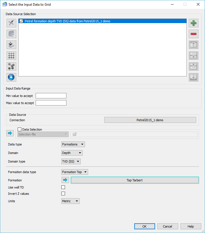
Petrel tops as input data to create a grid.
Following this, you add a Draw Map… task from the Tools menu. You need to have previously prepared a Template dbm that will be used as a template for the maps to be generated. You can either save the output as another dbm and/or plot the map to a raster file, plotting system or PDF file. In this example, we will plot the map to a PDF and will populate the parameters accordingly.
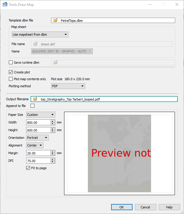
Draw Map task plotting the map to a PDF file.
Once you have your two tasks in the task list, run them and check the output for this first grid and map.
Now it’s time to set the looping task: highlight the two tasks, and from the Workflow menu, select Loop Over Highlighted Tasks… Alternatively, you can access the same option using the right mouse button (RMB) on the selected tasks.
In the Loop Parameter and Values panel, select Well formations or zones as your Loop input type (notice you have other options you can loop over, ie. seismic horizons) and choose Petrel as your Well Data Source. Establish the connection to the Petrel project. Again, notice all the 3rd party sources available you can use as input for the looping tops. Now proceed to add as many formations as you would like to include in the automatic creation of maps. Before closing the panel, choose a distinctive name for the User defined loop parameter, as this will need to be used when scripting the parameters [2].
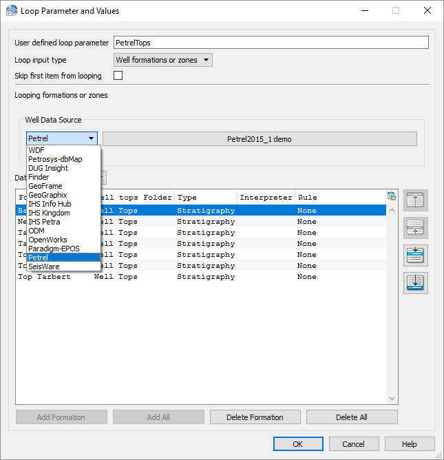
Loop parameter and Values panel. Well formations have been selected as the input type. Notice all the 3rd party sources available to use as input.
Now we need to identify and script the parameters that will allow the workflow to use a different formation from the list in every iteration. For additional info on how scripting works, take a look at the Workflows and Looping in Petrosys webinar recording on our YouTube channel, check the relevant topics in the Petrosys Online Help or contact Petrosys Support for assistance.
To do the scripting, highlight the task and select Task Parameters… from the Workflow menu (alternatively, access this option by selecting it from RMB menu). For the gridding task, the parameters to script are related to the input data and the output grid, which need to point to the User defined loop parameter previously defined.
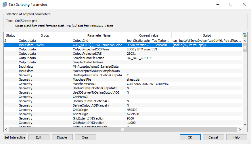
Script Parameters for the grid task. Notice the two parameters that have been scripted to point to the User defined loop parameter, which can be identified by the “S” in their status.
For the Draw Map task, you need to identify and script the parameters related to the grid created in the previous task, well tops from Petrel, output PDF name and the tops name to be inserted in the title block.
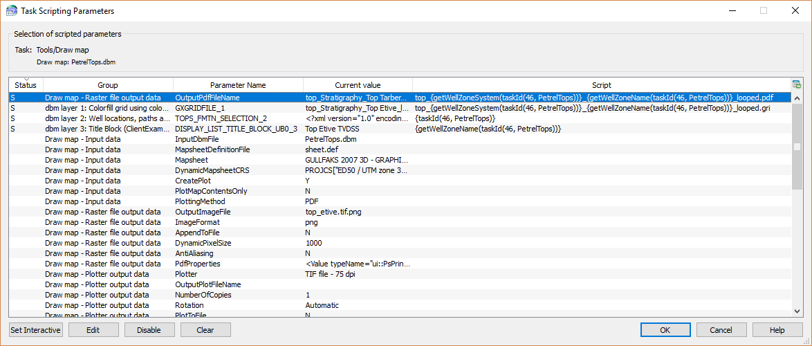
Script parameters for the Draw Map task.
Now you have scripted all the relevant parameters in the looping workflow and are ready to run the automated task. Run it and notice how it loops over your task list creating the relevant grid and map for every formation you have selected in your looping task.
Once the task has run, open the PDF maps located in your project directory and QC them. If they are right, go back to your task and save it as a tsk file.
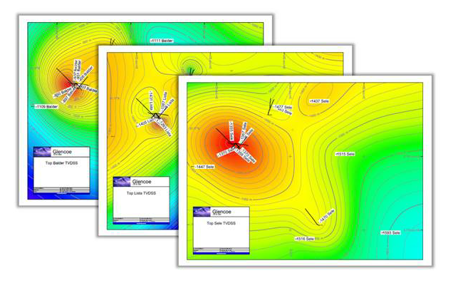
Series of PDF maps created automatically from a looping workflow.
You have now created an automated workflow that allows you to create updated maps for every formation, including an updated grid and, in this case, substituting the tops from a 3rd party source as a Petrel project.
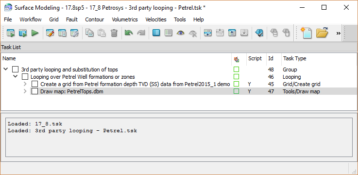
Looping workflow for the creation of grid and maps.
From now, whenever new well data is added to the Petrel project or the well tops have been reinterpreted, all you need to do to update the grids for every formation and to include new wells in your maps is to run this workflow in Petrosys and QC your PDF maps, thus saving a considerable amount of time.
[1] Contact Petrosys Support to know more about direct connections to 3rd party source.
[2] For more info on how to set a looping workflow, see the relevant topic in the Petrosys Online Help.