

Version 17.7, released on 2 September 2015, touches on a collection of usability, performance, connectivity, automation, direct data access, third-party connectivity and data footprint enhancements to optimise mapping workflows.
By connecting data and workflow pieces of the exploration and development puzzle together, version 17.7 continues to raise mapping standards and accelerate sub-surface programs.
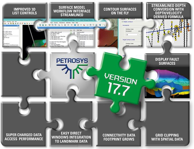
Some of the benefits clients can expect include:
Super-Charged Data Access with Automatic Caching
Enhancements to “cache” data read from third-party sources has been improved in version 17.7, delivering between 2 and 10 times data access performance acceleration.
When accessing data from any of the richly supported third-party connections, the data is automatically added to a local disk cache ready for the next map redraw or re-gridding operation. The cached data is shared amongst all applications started from the same Petrosys Launcher window, until such time as the Launcher is closed (when the cache is automatically cleaned).
The improvements were made to a number of types of data: Wells; 2D and 3D Seismic; Grids; and, GIS data.
The bottom line result… significantly improved performance.
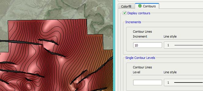
On-The-Fly Creation of Map Contours
The introduction of a “Contour” tab within the Grid and Seismic Surface display options in Petrosys Mapping means that contours can be computed and displayed directly on the gridded surface.
The contouring levels and parameters user interface has been upgraded to improve the ease of adding in multiple levels of styles as well as allow specific absolute levels to have specific styling. This accelerates the ability to easily display contours without the need to use the separate Surface Modeling application to import your surface and then compute contour files.
As a result, less data files are created and need to be managed which means that contours can be mapped more effectively.
Improved Depth Conversion by Directly Assessing the Depth/Velocity Relationship
A new option available in the Surface Modeling application automatically creates grid arithmetic tasks for depth conversion based on a formula derived from the depth/velocity relationship. The formula is generated from checkshot, formations/zones of selected wells.
The data points used are visually reviewed in a cross plot chart for analysis which also enables any outlier or error points to be excluded from the formula, creating a more accurate model fit.
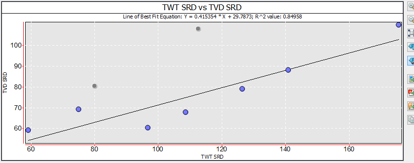
The derived formula is then used to automatically generate surface modeling tasks which depth convert your chosen time grid.
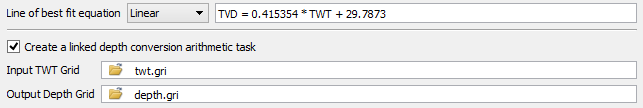
The option is available from within Surface Modeling using the “/Velocities/Well Checkshot Depth Conversion” menu option.
In addition to “Linear” line of best fit, Petrosys charts now support “Polynomial”, “Exponential”, “Power” and “Logarithmic” lines of best fit.
Simpler Transfer of Surfaces and Grids Between GeoFrame and OpenWorks
The Exchange framework has been extended to allow transfers between even more of your data sources. Seismic Surface Exchange now supports GeoFrame surfaces for input, while Grid Exchange adds OpenWorks as an output data source alongside GoCad and Rescue as new input sources. This simplifies the error prone process of transferring data between, for example, GeoFrame and OpenWorks to a single, repeatable task.
Easy Direct Connectivity to OpenWorks and SeisWorks (from Windows OS)
Direct support has been added for connecting to OpenWorks and SeisWorks (R5000.8 and R5000.10) on the Windows platform. Simply by installing the OpenWorks application on your Windows desktop, Petrosys can now connect to your OpenWorks and SeisWorks projects without the need for a dispatch server to be configured on Linux.
For a full list of the 17.7 features view the Release Notes, where you can also request a download. Alternatively, contact support@petrosys.com.au who will be happy to send you a link and installation instructions.