

- Create and manage standard reserves mapping content
- Show surfaces on maps in a universally established graphic form
- Ensure consistent reading independent of color and grayscale publishing quality
- Add personal geoscience input by editing contours and faults
- Display multiple versions and attributes of a structure on a singe map
Detailed Contours from Economical Grids
The advanced grid interpolation algorithms available with Petrosys grids allows Petrosys contouring to produce smooth contours that don’t cross one another even when computed on relatively coarse grid cell sizes.
As fault polygons are embedded in the Petrosys grid file, the contours can be traced very closely to the fault edges.
Manage and Edit Contours as Vector Data
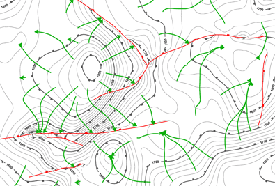
Orthocontours help analyse potential flow
paths.
Contours are computed and stored as vector data in Petrosys. Contours can be imported from other data sources such as GeoFrame, Zmap, Sattlegger and CPS, and exported to a range of formats including GIS structures such as ShapeFile and GoogleEarth KML. Contour files from adjacent areas can be merged, and bulk smoothing operations can be undertaken.
Petrosys contour files are coordinate reference system (CRS) aware, and can be displayed correctly on Petrosys maps in alternate projections and based on different geodetic datums.
Petrosys unique contour, fault and polygon editing tool provides intuitive functions for interactively editing contours, faults and general polygons, including the ability to construct polygons such as reservoir outlines from existing contour and fault line segments.
Presentation Quality Contour Displays
Petrosys contour rendering creates presentation quality displays with minimal effort. Different line and annotation styles can be applied to different groups of contour levels. Color gradients may be used for further differentiation of elevations or depths. Absolute line widths can be used to create very high quality raster images for publication.
As Petrosys contour lines have a sense of ‘which way is up’ a ticked line style can be used to indicate up or down slope directions.
For use with potential field data where extreme changes in slope may be encountered, a contour with blanking option allows for automatic suppression of the contour computation of selected levels in areas where steep gradients would create too dense a collection of contour lines.
From Contours Back to Grids
Edited or imported contours can be converted back to Petrosys grids by including them in the input data to a Petrosys gridding process, where a tailored resampling process ensures a realistic rendering of the contoured surface. A localised re-gridding option allows fast recomputation of grid patches based on small edited contour segments in large grids.